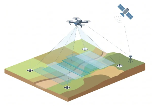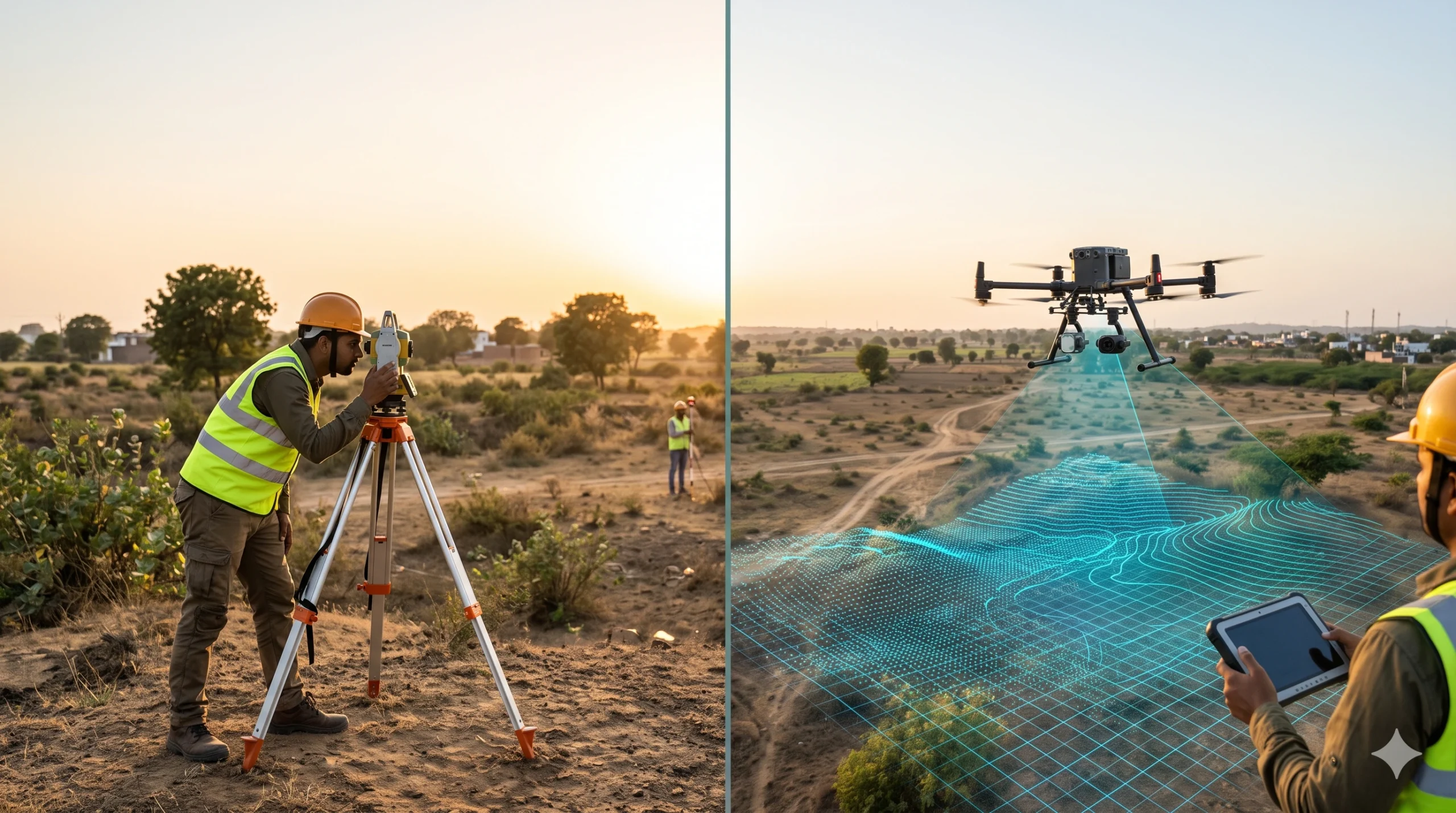
A traditional survey measures selected points on the ground with a total station, GNSS receiver or level, and records them as plans and contours. A drone aerial survey flies a UAV over the site, captures overlapping images or laser data, and processes them into maps, elevation models and 3D data that cover the entire surface. Drones win on speed, coverage and safety for large or hard-to-reach sites. Traditional methods win on precise control, boundaries and small plots. Our drone aerial survey services combine both, using DGPS survey control to anchor every drone map.
Drone Aerial Survey vs Traditional Survey at a Glance
- Data captured: Traditional records selected points. Drones record the full visible surface.
- Speed: Drones cover large areas in far less field time.
- Accuracy: Traditional is very precise at measured points. Drones reach centimetre-level with RTK/PPK and ground control.
- Safety: Drones keep crews away from steep, unstable or hazardous ground.
- Outputs: Drones give orthomosaics, DSM, DTM, contours, point clouds and 3D models. Traditional gives points and plans.
- Limits: Drones are affected by weather and airspace rules and cannot see the ground under dense canopy with photogrammetry.
- Best practice: Use traditional control and checks to anchor and validate drone data.
What is a Traditional Survey?
A traditional survey is a ground-based method where a surveyor decides which points matter and measures them one by one. The data is then drawn as plans, profiles, sections and contour maps.
- Total station: Measures angles and distances to selected points. See our total station survey services.
- GNSS / DGPS receivers: Fix positions with satellites in open sky.
- Digital or optical levels: Measure heights and level lines.
- Tapes and chains: Used for short offsets and boundary checks.
These tools are proven and very accurate at each measured point. Their limit is coverage: you only get the points the crew had time to measure.
What is a Drone Aerial Survey?
A drone aerial survey uses an unmanned aerial vehicle with a camera or LiDAR sensor to capture the site from the air. Software processes the data with ground control into georeferenced maps and 3D models. For the full process, equipment and deliverables, read our guide on what is a drone aerial survey.
Key Differences: Drone Aerial Survey vs Traditional Survey
| Factor | Traditional Survey | Drone Aerial Survey |
|---|---|---|
| Data captured | Selected points chosen by the surveyor | Millions of points over the whole visible surface |
| Speed on large areas | Slow; days to weeks of fieldwork | Fast; hours to days of flying |
| Accuracy | High at measured points | Centimetre-level possible with RTK/PPK and GCPs |
| Terrain model | Interpolated between points | Built from dense surface data |
| Under vegetation | Slow but possible on foot | Photogrammetry cannot see the ground; LiDAR can through gaps |
| Safety | Crew walks the whole site | Remote capture reduces exposure |
| Weather | Works in most conditions except heavy rain | Limited by strong wind, rain and low light |
| Missed data risk | High; revisits are common | Low; measure later from the dataset |
| Deliverables | Points, plans, contours | Orthomosaic, DSM, DTM, contours, point cloud, 3D model |
| Regulation | No airspace rules | Drone Rules, 2021 and airspace permissions apply |
| Cost | Lower for small plots | Often better value for large or complex sites |
1. Accuracy and Reliability
A total station or DGPS receiver is very accurate at each point it measures, and for setting out and boundary pins it remains the right tool. The weakness of a point-based survey is what happens between the points: terrain is assumed to change smoothly, so small ridges, ditches and mounds can be missed.
A drone records the whole surface. With RTK or PPK positioning, well-spread ground control points and proper flight planning, drone photogrammetry can reach centimetre-level horizontal accuracy, with vertical accuracy usually slightly lower. Always ask for an accuracy report based on independent check points that were not used in processing.
2. Speed and Field Time
Manual surveys scale with area: bigger site, more crew days. Drone surveys scale mostly with processing. One published Indian guide from Axesmap describes a 100-acre example where a ground team needs roughly 15 to 20 working days while a drone team needs 1 to 2 field days plus a few days of processing. Treat that as one provider’s illustration, since actual time depends on terrain, vegetation and deliverables, but the direction is consistent across projects: drones save the most time on large, open sites.
3. Coverage and Completeness of Data
With a traditional survey, if the designer later needs a cross-section at a new location, the crew may have to return. A drone dataset stores the full surface digitally, so new contours, profiles and volumes can be produced without going back. This matters in construction monitoring, mining and land development, where the same site is measured again and again.
4. Safety and Access
Steep slopes, quarries, floodplains, railway corridors, live highways and unstable ground are risky for walking crews. A drone captures the data from a safe distance and reduces time spent in danger zones. For difficult access, it is often the only practical choice.
5. Vegetation and Terrain
Photogrammetry sees only what the camera sees. Where trees or crops hide the ground, the drone model shows the canopy, not the soil. In that case, use drone-mounted LiDAR, which can reach the ground through gaps. See our LiDAR survey services and the guide on LiDAR survey vs traditional survey methods. In dense forest or heavy undergrowth, ground survey may still be needed to check key points.
6. Deliverables
- Traditional: Point lists, plans, sections and contour maps.
- Drone: Orthomosaics, DSM and DTM, contours at any interval, point clouds, 3D meshes, volume reports and GIS layers.
Drone outputs integrate easily with GIS and mapping, design software and visual tools such as 3D virtual reality. Contour work is covered under our contour survey services.
7. Cost: Upfront vs Total Value
For a small plot, a traditional survey is usually cheaper and fully adequate. For large or uneven sites, a manual survey can need weeks of crew time, while a drone reduces field time and revisits. A fair comparison looks at total project cost, including delays and rework. To understand drone pricing, read drone aerial survey cost in India.
8. Regulations and Permissions
Traditional surveys do not need airspace permission. Drone surveys in India follow the Drone Rules, 2021 and the airspace map on the Digital Sky platform. Flights in green zones up to 400 feet generally need no flight permission, while yellow and red zones, such as areas near airports, need approval. If your site is near an airport, read AAI NOC vs DGCA clearance and see our Airport NOC survey services. Rules change from time to time, so always check the current map.
Limitations of Each Method
Traditional survey
- Only selected points are recorded
- Slow and labour-intensive on large areas
- Revisits are common when data is missing
- Crew must access every part of the site
Drone aerial survey
- Photogrammetry cannot see the ground under dense vegetation
- Wind, rain, low light and shadows reduce quality
- Battery life limits flight time per mission
- Airspace rules and permissions apply
- Accuracy depends on ground control and skilled processing
When to Choose a Traditional Survey
- Small plots, single buildings or short boundaries
- Setting out, staking and as-built checks of specific points
- Precise control networks and benchmarks
- Legal boundary demarcation needing physical markers, as in cadastral and land survey
- Restricted airspace where flying is not allowed
When to Choose a Drone Aerial Survey
- Large areas where speed matters
- Corridors such as roads, canals, pipelines and power lines
- Mines, quarries and stockpile volume work
- Construction progress monitoring with repeat surveys
- Hazardous, steep or inaccessible sites
- Projects that need an orthomosaic, contours and a 3D model from one flight
Governments use drones at large scale too. India’s SVAMITVA Scheme maps inhabited rural land with drones to issue property cards.
The Hybrid Approach: Best of Both
The strongest projects use both. A DGPS or total station team sets ground control points and check points, and the drone captures everything between them. Control keeps absolute accuracy high, and the drone fills in the surface. The same idea applies to buildings, where laser scanning and manual control are combined in Scan to BIM vs traditional survey workflows.
How to Decide: Quick Checklist
- Is the area large or the shape long and narrow? Lean towards a drone.
- Is the terrain steep, hazardous or hard to walk? Choose a drone.
- Do you need contours, volumes and a map from one dataset? A drone is efficient.
- Is the ground covered by dense vegetation? Use drone LiDAR or ground survey.
- Is the plot small and simple? A traditional survey may be enough.
- Do you need legal boundary pins or setting out? Use traditional methods as well.
- Is flying restricted at your location? Plan permissions or use ground methods.
Survey Services Across India
Surveying India supports drone, LiDAR and ground survey projects across India. For local laser-based survey support, see our pages for Mumbai, Pune, Delhi, Gurugram, Noida, Greater Noida, Bengaluru, Hyderabad, Chennai, Kolkata and Ahmedabad.
For building documentation, read our guides on what is Scan to BIM survey and Scan to BIM survey cost in India, or visit our Scan to BIM survey services. We also cover landscape survey and multispectral NDVI solutions. Local Scan to BIM pages: Mumbai, Pune, Delhi NCR, Bengaluru, Hyderabad, Chennai, Kolkata and Ahmedabad.
Frequently Asked Questions
What is the difference between a drone survey and a traditional survey?
A traditional survey measures selected points on the ground with a total station, GNSS or level. A drone survey captures images or laser data from the air and produces maps and 3D models of the whole surface.
Is a drone survey as accurate as a traditional survey?
With RTK or PPK positioning and good ground control, drone surveys can reach centimetre-level accuracy suitable for many engineering uses. Traditional methods remain the best choice for precise points, setting out and legal boundaries.
Is a drone survey faster than a traditional survey?
On large or uneven sites, yes. Drones cover wide areas in hours or days, while ground teams can take weeks. On a small plot, a manual survey can be just as quick.
Is a drone survey cheaper than a traditional survey?
For large or difficult sites, often yes in total cost because it needs less field time. For small plots or boundary work, a traditional survey can be cheaper.
Can a drone survey replace a total station survey?
Not completely. Drones give dense surface data, but total station and DGPS are still needed for ground control, check points, setting out and boundary marking. The best results combine both.
Can drones survey areas with trees and dense vegetation?
Photogrammetry cannot see the ground under dense canopy. Drone-mounted LiDAR can capture ground through gaps in the canopy, and ground survey may still be used to verify key points.
Do drone surveys need government permission in India?
Under the Drone Rules, 2021, flights in the green zone up to 400 feet do not need flight permission, while yellow and red zones, such as areas near airports, need approval. Check the Digital Sky airspace map before flying.
When should I use a traditional survey instead of a drone?
Choose traditional methods for small plots, setting out, precise control networks, legal boundary demarcation, or where flying is restricted.
Do drone surveys need ground control points?
Yes, for reliable accuracy. Ground control points and independent check points tied to DGPS or total station surveys georeference the data and verify the final result.
What is the best approach: drone, traditional or both?
For most professional projects, both. Use traditional survey for control and checks, and use the drone to capture the full surface quickly and safely.
Conclusion
Drone aerial survey and traditional survey are not rivals. Traditional methods give precise control and are practical for small, simple jobs and legal boundaries. Drones give speed, full coverage and safer access on large, uneven or hard-to-reach sites. The strongest results come from combining them: survey-grade ground control with full-surface drone capture, delivered with clear accuracy checks.
Not sure which method fits your project? Explore our drone aerial survey services or contact our team for a scope-based recommendation. You can also email info@surveyingindia.in.