Best BIM Scanning Services in Delhi NCR
Construction projects across Delhi NCR are growing fast, but one problem keeps slowing teams down — outdated drawings that don’t match real site conditions. A small error in a wall, pipeline, or structural layout can cause expensive delays and rework.
This is exactly why BIM scanning services in Delhi have become essential for architects, engineers, and construction teams. Surveying India brings 10+ years of experience in BIM scanning, 3D laser scanning, LiDAR mapping, and geospatial engineering, with completed projects across residential, commercial, industrial, and heritage sectors.
This guide explains what BIM scanning involves, what to look for in a provider, and why Surveying India is a trusted name for this work in Delhi NCR.
.
What Is BIM Scanning and Why It Matters in Delhi NCR
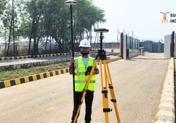
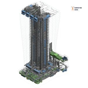
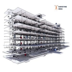
BIM scanning (also called Scan to BIM) uses a 3D laser scanner to capture millions of data points from a physical structure within minutes. This data, known as a point cloud, is then converted into a Building Information Model — a precise digital replica of the real building.
Delhi NCR’s mix of decades-old buildings and new commercial towers makes accurate as-built documentation essential, not optional. Whether the goal is renovation planning, MEP coordination, or a facility audit, BIM scanning services in Delhi give teams a dependable foundation to build on.
This approach is widely used for heritage building documentation, commercial fit-outs, metro infrastructure projects, and industrial plant upgrades across the region.
Why Surveying India for BIM Scanning Services in Delhi
Scanning and modeling under one roof
Most providers outsource BIM modeling to a separate team after capturing the scan, which slows delivery and creates communication gaps. At Surveying India, the same in-house team handles scanning and modeling end-to-end — fewer errors, faster turnaround, and one point of contact throughout.
Surveying India offers end-to-end BIM scanning services in Delhi — from on-site 3D laser scanning to full BIM model delivery. They work across residential, commercial, industrial, and heritage sectors. What makes them stand out is that scanning and modeling are handled by the same in-house team, which means fewer errors, faster delivery, and cleaner communication.
Experience on Critical Infrastructure Projects
Surveying India has contributed to surveying and geospatial projects in highly regulated infrastructure environments, including Delhi Airport. Projects in active airport zones demand precise data collection, strict safety compliance, coordinated site access, and adherence to operational protocols.
Our team has experience working in environments where accuracy and reliability are essential, delivering survey data that supports engineering, planning, and infrastructure development activities. This exposure to complex, high-security projects strengthens our ability to execute demanding assignments across commercial, industrial, and public-sector developments throughout India.
Trusted Across Diverse Project Types
From airports and transportation infrastructure to industrial facilities, commercial developments, and large-scale real estate projects, Surveying India applies the same focus on accuracy, documentation, and timely delivery. Our experience across sectors enables us to provide dependable survey solutions tailored to each project’s requirements.
Other BIM Scanning Providers in Delhi NCR
For context, here’s how Surveying India compares to other firms active in the region:
- Surveying India — End-to-end scanning and modeling in-house, covering residential, commercial, industrial, and heritage projects.
- Leica Geosystems Certified Partners — Best for clients needing raw, high-accuracy point cloud data only.
- 3D Scan India (Noida) — Specializes in industrial plant and MEP scanning.
- Geoid Technologies — Strong in large-scale infrastructure and topographic projects.
- BIM Outsourcing India — Covers full LOD spectrum for architectural documentation.
- Tejjy Inc. — BIM consulting with clash detection and 4D/5D coordination.
- Spatial Vision India — Combines laser scanning with photogrammetry for campuses.
- Cresire Consultants — Focused on LEED/green building BIM workflows.
- Dimension Imaging (Delhi) — 3D documentation for real estate and interiors.
- Hindustan Surveys — Traditional surveying firm now offering scan to BIM.
What to Look for When Hiring a BIM Scanning Company
Scanner quality and accuracy
Ask which scanner models are used. Professional equipment like the Leica BLK360 G2 or FARO Focus delivers accuracy within ±1mm, while cheaper equipment produces noisy point clouds that cause modeling errors later. Surveying India’s LiDAR scanning services in Delhi use industry-grade equipment for this exact reason.
Level of Detail (LOD) capability
A basic spatial model for renovation (LOD 200–300) is very different from a detailed MEP coordination model (LOD 400–500). Confirm the provider can match the LOD your project needs.
In-house vs. outsourced modeling
Providers that outsource BIM conversion after capturing the scan add time and reduce quality control. Look for teams that handle both scanning and modeling internally.
File format compatibility
Confirm deliverables work with your design software — common formats include Revit (.rvt), IFC, AutoCAD (.dwg), and point cloud formats like .las or .e57.
Common mistakes to avoid
Choosing a provider on price alone, not defining LOD requirements upfront, ignoring file format compatibility until after delivery, skipping site prep (which causes scan registration errors), and forgetting to ask about post-delivery revision support.
FAQs About BIM Scanning Services in Delhi
How long does a BIM scanning project typically take? It depends on the structure’s size. A single office floor can be scanned and modeled in 3–5 working days. A large commercial building or industrial plant may take 2–4 weeks, including point cloud processing and BIM conversion.
How accurate is 3D laser scanning for BIM? Professional-grade scanners deliver accuracy within ±1–3mm under normal site conditions — more than sufficient for architectural, structural, and MEP documentation.
Can BIM scanning be used for old or heritage buildings in Delhi? Yes, it’s one of the best use cases. Heritage structures often have irregular shapes that are difficult to measure accurately by hand, and laser scanning captures every surface detail without physical contact.
What file formats will I receive? Most providers deliver in Revit (.rvt), IFC, AutoCAD (.dwg), and point cloud formats like .las or .e57. Always confirm compatibility with your design software before starting.
How do I choose the right BIM scanning service provider in Delhi? Start by defining your LOD requirement and file format needs, shortlist providers with relevant project experience, and ask for sample deliverables before signing anything.
Final Thoughts
Demand for BIM scanning services in Delhi NCR will keep growing as construction becomes more complex and data-driven. Whether you’re retrofitting an old structure, coordinating MEP systems in a new tower, or documenting a heritage site, the right partner makes a measurable difference to project outcomes.
If you want a team that handles scanning and modeling in-house, communicates clearly, and delivers precise models on time — Surveying India is worth your first call.
Visit surveyingindia.in to learn more or get a project quote.