
360° Virtual Tour & Panorama Photography for Real Estate and Infrastructure
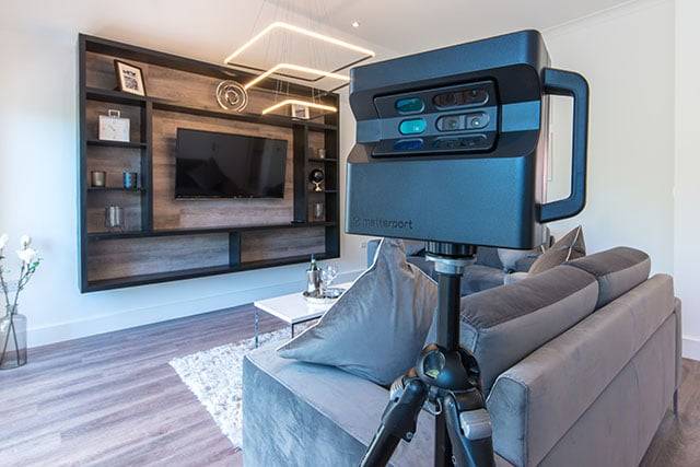
Surveying India delivers professional 3D virtual tour and 360° panorama photography services across India, helping real estate developers, infrastructure firms, and property owners showcase spaces through immersive, walk-through visuals. Using Matterport-based digital visualization and high-resolution HDR panoramic imaging, our team turns physical locations into interactive online tours that buyers, tenants, and project stakeholders can explore remotely — cutting down unnecessary site visits and speeding up decisions.
Backed by 10+ years of geospatial and survey experience, we pair precise on-site capture with professional panorama stitching, color correction, and ghost/haze removal to produce clean, realistic imagery — for property listings, construction documentation, and client walkthroughs.
Whether it’s a residential project, a commercial space, or a large infrastructure site, our 3D virtual tour services give clients a reliable way to see, evaluate, and plan without stepping on site.
What Is a 3D Virtual Tour?
A 3D virtual tour is an interactive, walk-through digital representation of a physical space, built from stitched 360° panoramic photographs. Unlike a single photo or video, a virtual tour lets viewers navigate a property or site room-by-room, from any device, without visiting in person. It’s commonly used for real estate marketing, construction documentation, and remote site inspection — and, when built on the Matterport platform, it can also generate accurate floor plans and measurements alongside the visual tour. This pairs naturally with our scan to BIM and 3D scanning point cloud services for teams needing both visual and dimensional documentation.
What We Offer
- High-Resolution HDR Imaging – Every detail captured with accurate color and lighting, even in mixed indoor/outdoor conditions.
- Matterport-Based Virtual Tours – Walk-through 3D tours with auto-generated floor plans, suited for real estate and facility documentation.
- Vertical & Horizontal Panorama Stitching – Flexible capture for both indoor rooms and open outdoor spaces.
- Color Correction & White Balance – Realistic, consistent tones across every stitched image.
- Ghosting & Haze Removal – Clean output free of stitching artifacts or atmospheric haze.
- Fast Turnaround – Fast Turnaround – Delivered within 1 business day
Who This Service Is For
- Real estate developers & brokers – Let buyers walk through a property before scheduling a physical visit.
- Construction & infrastructure teams – Document site conditions for progress records, compliance, and remote stakeholder review, alongside our LiDAR survey and GIS & Mapping services for complete site documentation.
- Hospitality & commercial spaces – Give potential clients a realistic sense of a venue online.
- Facility managers – Maintain an accurate, navigable visual record of a site over time.
Our Process
- Site Scoping Call – We confirm space size, access, and delivery format.
- On-Site 360° Capture – HDR panoramic photography using Matterport or equivalent capture hardware, often paired with our drone aerial survey service for large outdoor or infrastructure sites.
- Stitching & Post-Processing – Color correction, haze/ghosting removal, seamless blending.
- Delivery – Hosted virtual tour link, downloadable panoramas, or embed code for your website or listing.
Why Choose Surveying India
Surveying India brings 10+ years of geospatial and survey experience to every virtual tour project, backed by DGCA-compliant drone operations and ISRO-aligned GIS standards across our broader service line. That same precision-first approach carries into our 3D virtual tour work — accurate, consistent, and delivered on schedule. Explore our full range of survey services to see how virtual tours fit into a broader documentation package.
Frequently Asked Questions
What is a 3D virtual tour?
A 3D virtual tour is an interactive digital walkthrough of a physical space, built from stitched 360° panoramic photos. Viewers can navigate the space room-by-room from a browser or phone, without visiting in person — commonly used for real estate listings, construction documentation, and remote site review.
Is a 3D virtual tour the same as virtual reality (VR)?
Not exactly. A 3D virtual tour is viewable on any standard device (phone, laptop, tablet) and doesn’t require a VR headset. True VR typically needs headset hardware for full immersion. Most real estate and property virtual tours — including Matterport-based tours — fall into the former category.
What is Matterport, and do you use it?
Matterport is a leading 3D capture platform used to create interactive virtual tours with automatically generated floor plans. Surveying India offers Matterport-based virtual tour services across India for real estate, construction, and facility documentation.
How much does a 360° virtual tour cost in India?
Pricing depends on the size of the space, number of capture points, and delivery format (hosted tour vs. downloadable panoramas)
How long does it take to create a virtual tour?
On-site capture for a typical residential or commercial unit takes a few hours; final delivery, including stitching and processing, is usually completed within 1 Day
Which cities does Surveying India cover for virtual tour photography?
Surveying India provides 3D virtual tour and panorama photography services across India, with active operations based out of Gurugram and coverage across Delhi NCR and other major cities.
Can a virtual tour be used for construction or infrastructure sites, not just real estate?
Yes. Virtual tours are increasingly used for as-built documentation, remote progress monitoring, and compliance records on construction and infrastructure projects, in addition to real estate marketing.
Ready to bring your property or project site to life online? Request a free quote and our team will get back to you within one business day.