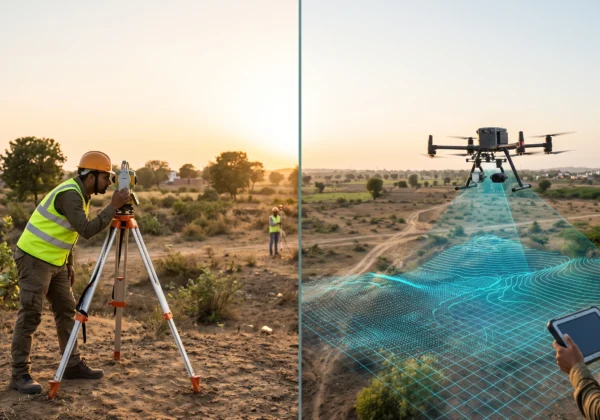
A drone aerial survey uses an unmanned aerial vehicle (UAV) fitted with a camera or LiDAR sensor to capture overlapping images or laser data of land from the air. The data is processed into georeferenced outputs such as orthomosaic maps, elevation models, contours, 3D models and volume reports. It is faster and safer than manual surveying for large or hard-to-reach sites. Our drone aerial survey services combine RTK-GNSS ground control with survey-grade processing, and work alongside our GIS and mapping services for ready-to-use maps.
Drone Aerial Survey at a Glance
- What it is: Mapping land from the air using a drone with a camera, LiDAR or other sensors.
- How it works: Overlapping images or laser pulses are processed with ground control into accurate maps and 3D data.
- Main outputs: Orthomosaic, DSM, DTM, contours, point cloud, 3D mesh, volume reports.
- Drone types: Multirotor, fixed-wing and VTOL hybrid.
- Best for: Topographic mapping, construction, mining, roads, solar, power lines, land records and agriculture.
- Key strength: Fast coverage of large areas with less field time and safer access.
- Rules in India: Drone Rules, 2021 apply, with the Digital Sky airspace map and permissions near airports.
What is a Drone Aerial Survey?
A drone aerial survey, also called a UAV survey or drone mapping, is a method of collecting spatial data from a low-flying drone instead of walking the site with a total station or GNSS receiver. The drone flies a planned grid at a set height and captures thousands of geotagged images. Software stitches them into an accurate map and 3D model. When fitted with a laser scanner, the same drone can also produce a dense point cloud, as explained in our guide on what is a LiDAR survey.
The main advantage is coverage. A survey team can map large areas in a fraction of the time manual methods need, and the data covers the whole surface rather than selected points.
How Does a Drone Aerial Survey Work?
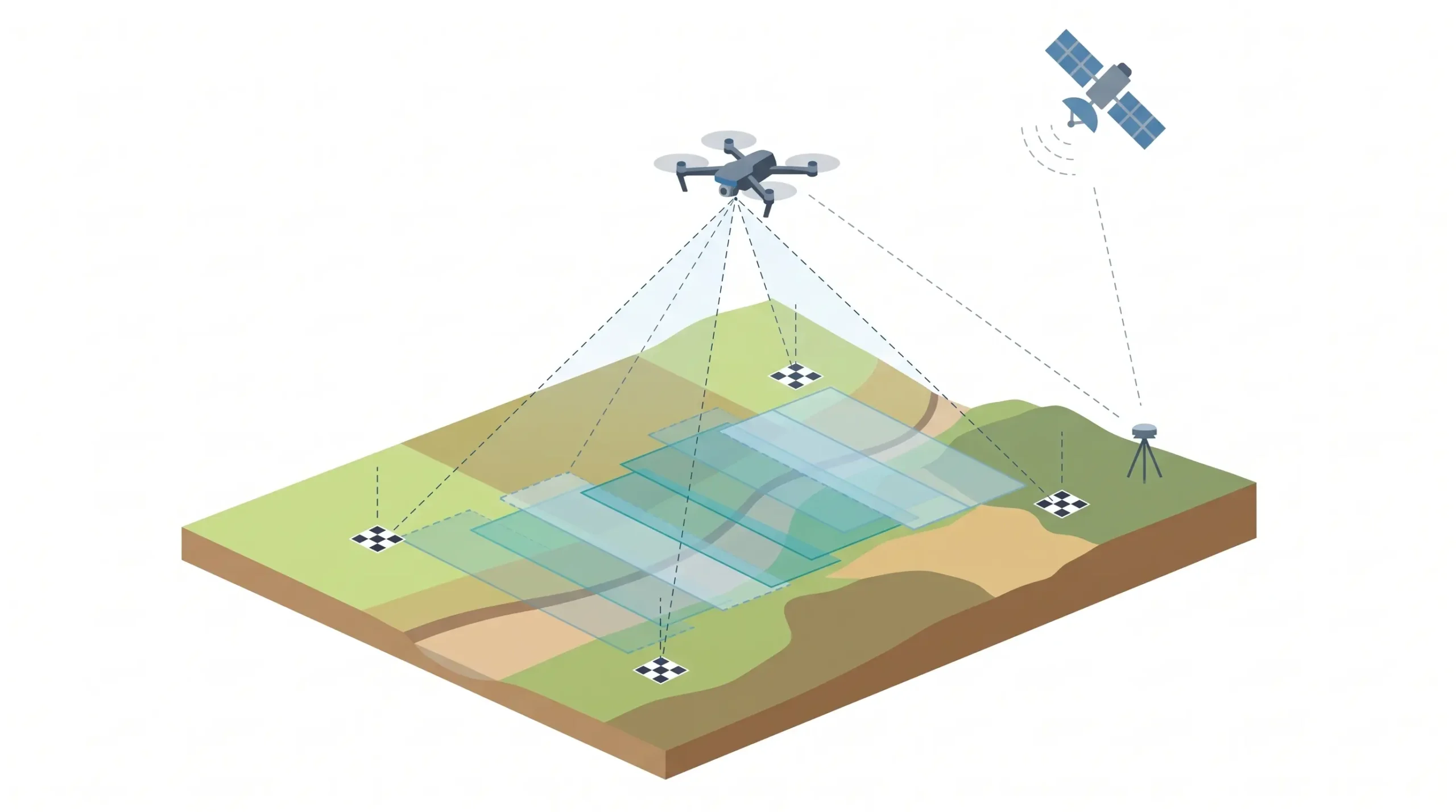
Most drone mapping uses photogrammetry. The camera takes overlapping photos, usually 70% to 80% forward and 60% to 70% side overlap. Software finds the same features in several photos and calculates their position in 3D. Accuracy comes from three things:
- Ground Sampling Distance (GSD): The size of one image pixel on the ground. Lower GSD means finer detail, and it depends on flying height and camera.
- Ground Control Points (GCPs): Surveyed markers on the ground, measured with RTK-GNSS or DGPS survey, which tie the model to real coordinates.
- RTK or PPK positioning: The drone records its own centimetre-level position during the flight, which reduces the number of GCPs needed.
Types of Drones Used in Aerial Surveys
| Drone Type | Best For | Notes |
|---|---|---|
| Multirotor | Small to mid-size sites, corridors, inspection | Easy launch, hovers, shorter flight time |
| Fixed-wing | Large areas, long corridors | Long endurance, needs launch and landing space |
| VTOL hybrid | Large areas without runway space | Vertical take-off with long flight time |
Sensors and Payloads
- RGB camera: For orthomosaics, 3D models and visual maps.
- LiDAR: For dense elevation data, even under vegetation gaps. See our LiDAR survey services.
- Multispectral: For crop health and vegetation index analysis. See our multispectral NDVI solutions.
- Thermal: For solar panel inspection, heat leaks and utilities.
The Drone Aerial Survey Process, Step by Step
1. Planning and Scoping
The team defines the area, accuracy, GSD, deliverables and coordinate system. Airspace is checked on the Digital Sky platform, and permissions are arranged where needed.
2. Ground Control Setup
GCPs and check points are placed and surveyed with RTK-GNSS or a total station. Check points are kept aside to verify accuracy later.
3. Flight Planning
Flight lines, height, speed and image overlap are set in planning software. Terrain-following is used on uneven ground to keep GSD consistent.
4. Data Acquisition
The drone flies the mission and captures images or LiDAR data. Weather, wind, light and battery are monitored throughout.
5. Processing
Images are aligned, a point cloud and mesh are built, and the model is georeferenced with the GCPs. Ground classification separates terrain from objects.
6. Output Generation
The processed data becomes orthomosaics, DSM and DTM, contours, cross-sections, volumes and 3D models. Contour work links directly to our contour survey services.
7. Quality Check and Delivery
Accuracy is tested against check points, and a report is prepared. Files are delivered in formats such as GeoTIFF, LAS/LAZ, DXF/DWG, SHP and PDF.
Drone Survey Deliverables
- Orthomosaic: A distortion-corrected, georeferenced aerial map.
- DSM and DTM: Surface model with objects and bare-earth terrain model.
- Contour maps: At the interval your design needs.
- Point cloud and 3D mesh: For modelling and measurement.
- Volume reports: For stockpiles, cut and fill.
- Feature maps: Roads, buildings, boundaries and utilities for GIS.
- Visualisation: Walkthroughs and immersive models. See our 3D virtual reality survey services.
How Accurate is a Drone Aerial Survey?
With RTK or PPK positioning, good GCPs and proper flight planning, drone photogrammetry can reach centimetre-level horizontal accuracy, and vertical accuracy is usually a little lower. Actual results depend on GSD, terrain, overlap, ground control and processing. Vegetation hides the ground from photographs, so heavily forested areas are better surveyed with LiDAR. Always ask for an accuracy report based on independent check points.
Applications of Drone Aerial Survey
- Topographic and contour mapping: Base maps for design and planning.
- Construction monitoring: Progress tracking and earthwork volumes.
- Mining and quarries: Stockpile volumes and pit progress.
- Roads, railways and canals: Corridor mapping and alignment studies.
- Solar and wind projects: Site layout, terrain and inspection.
- Power transmission lines: Route survey and asset inspection.
- Land records and cadastral work: Parcel mapping. See our cadastral and land survey services.
- Agriculture: Crop health and field mapping.
- Landscape and urban planning: See our landscape survey services.
India’s government also uses drone mapping at scale. The SVAMITVA Scheme uses drones to map inhabited rural land so property cards can be issued.
Drone Survey vs Traditional Survey vs LiDAR
| Factor | Drone Photogrammetry | Traditional (Total Station / GNSS) | Drone / Airborne LiDAR |
|---|---|---|---|
| Coverage speed | Fast on large areas | Slow | Fast |
| Data density | High, surface from images | Low, selected points | Very high, millions of points |
| Under vegetation | Cannot see the ground | Slow but possible | Can reach ground through gaps |
| Output | Orthomosaic, 3D model, DSM | Points, plans | Point cloud, DTM, contours |
| Cost | Moderate | Low for small plots | Higher |
| Safety | Remote capture | Crew on site | Remote capture |
For a detailed comparison of laser methods with manual surveys, read our guide on LiDAR survey vs traditional survey methods.
Benefits and Limitations
Benefits
- Fast coverage of large and hard-to-reach areas
- Less field time and fewer people on hazardous ground
- Full-surface data with repeatable surveys for progress tracking
- Multiple outputs from one flight
- Lower cost than manned aircraft for mid-size sites
Limitations to know
- Photogrammetry cannot see the ground under dense vegetation
- Wind, rain, low light and shadows reduce data quality
- Battery life limits flight time per mission
- Airspace rules and permissions apply, especially near airports
- Accuracy depends on good ground control and skilled processing
Drone Survey Rules in India
Drone operations in India follow the Drone Rules, 2021, issued by the Ministry of Civil Aviation. The Digital Sky platform hosts the airspace map and approvals. In short:
- Green zone: Airspace up to 400 feet (120 m) not marked red or yellow. No flight permission is needed for permitted drones.
- Yellow zone: Controlled airspace, including areas close to airports. Permission from the relevant air traffic control authority is required.
- Red zone: No-drone zone, with operations only under government authorisation.
Commercial survey flights should be run by trained remote pilots using registered drones. Rules are updated from time to time, so check the current airspace map before every project.
Drone Surveys Near Airports
If your survey site is close to an airport, two things can apply: drone flight permission in the yellow or red zone, and, if you plan a tall structure there, an AAI height clearance NOC. They are different approvals. Read AAI NOC vs DGCA clearance and our Airport NOC survey services to see how they differ.
What Affects Drone Survey Cost?
- Area and shape of the site
- Required accuracy and GSD
- Sensor: RGB, LiDAR, multispectral or thermal
- Number of GCPs and terrain difficulty
- Deliverables: Orthomosaic only costs less than contours, DTM, models and reports
- Permissions, location and turnaround time
Always request a scope-based quotation. For pricing context on laser-based surveys, see LiDAR survey cost in India.
How to Choose a Drone Survey Company
- Do they own survey-grade drones with RTK or PPK and trained, certified remote pilots?
- Do they use GCPs and share an accuracy report based on check points?
- Can they process data into contours, DTM, orthomosaics and GIS files in-house?
- Do they handle airspace permissions and compliance?
- Can they show similar completed projects?
- Do they offer ground survey support such as total station survey?
Drone Mapping for Buildings and Digital Models
Drone data can also support building and site modelling. For detailed building-level documentation, read our guide on what is Scan to BIM survey, our Scan to BIM survey services and Scan to BIM vs traditional survey.
Survey Services Across India
Surveying India supports drone, LiDAR and ground survey projects across India. For local laser-based survey support, see our pages for Mumbai, Pune, Delhi, Gurugram, Noida, Greater Noida, Bengaluru, Hyderabad, Chennai, Kolkata and Ahmedabad.
For building documentation, we also offer Scan to BIM in Mumbai, Pune, Delhi NCR, Bengaluru, Hyderabad, Chennai, Kolkata and Ahmedabad. For cost context, read Scan to BIM survey cost in India.
Frequently Asked Questions
What is a drone aerial survey in simple words?
It is a method where a drone flies over a site, captures images or laser data, and the data is processed into accurate maps, elevation models and 3D models.
How accurate is a drone survey?
With RTK or PPK positioning and good ground control, drone photogrammetry can reach centimetre-level horizontal accuracy. Vertical accuracy is usually slightly lower, and results depend on flight planning and processing.
What is the difference between drone survey and LiDAR survey?
A drone survey usually uses a camera and photogrammetry. A LiDAR survey uses laser pulses and can reach the ground through vegetation gaps. A drone can carry either sensor.
What deliverables do I get from a drone survey?
Common deliverables are orthomosaic maps, DSM and DTM, contours, point clouds, 3D models and volume reports in formats such as GeoTIFF, LAS, DXF and PDF.
What are drone aerial surveys used for?
They are used for topographic mapping, construction monitoring, mining volumes, road and rail corridors, solar and wind projects, land records, agriculture and utility inspection.
Do I need permission for a drone survey in India?
Under the Drone Rules, 2021, flights in the green zone up to 400 feet do not need flight permission, while yellow and red zones need approval. Check the Digital Sky airspace map before flying.
How long does a drone survey take?
Field flying can take hours to a few days depending on area and weather. Processing and delivery take days to a couple of weeks, depending on the deliverables.
Can drones survey areas covered with vegetation?
Photogrammetry cannot see the ground under dense canopy. LiDAR can capture ground through gaps, so it is better for forested or heavily vegetated terrain.
Is a drone survey cheaper than a traditional survey?
For large or difficult sites, usually yes in total cost, because it needs less field time. For very small plots, a traditional survey can be cheaper.
Why are ground control points needed in a drone survey?
GCPs tie the drone model to real-world coordinates and improve absolute accuracy. Independent check points are used to verify the final result.
Conclusion
A drone aerial survey turns a site into measured, usable data quickly and safely. It works best when it is planned well: clear scope, correct sensor, solid ground control and a team that handles processing and compliance. Pair drone data with traditional control and, where needed, LiDAR or GIS, and you get maps you can build on with confidence.
Planning a project? Explore our drone aerial survey services or contact our team for a scope-based quotation. You can also email info@surveyingindia.in.