Ever wondered why some buildings near an airport get approved by the local municipal office in days, while others wait months for AAI’s sign-off? The colour coded zoning map AAI system is usually the answer.
The colour coded zoning map AAI publishes is a grid-based map that shows the Permissible Top Elevation (PTE) for every location around a major airport. It lets local municipal bodies approve building proposals directly, without referring the case to AAI, as long as the requested height stays within the mapped limit. Where a CCZM exists, it can turn a weeks-long NOCAS application into a same-week municipal approval.
This guide explains what the colour coded zoning map actually is, how AAI prepares it, what the colour zones mean, and why it matters for anyone planning construction near an airport.
What is the Colour Coded Zoning Map (CCZM)?
Under Rule 6 of GSR 751(E), the Airports Authority of India (AAI) has the authority to issue Colour Coded Zoning Maps for civil aerodromes across India. Each CCZM divides the area around an airport into a grid. Every grid cell carries a colour. Each colour corresponds to a Permissible Top Elevation (PTE) figure, measured Above Mean Sea Level (AMSL).
AAI first issued formal CCZM guidelines on 18th August 2017. Coverage has expanded steadily since then. As of recent updates, roughly 30 major airports across India have a published CCZM. This includes cities such as Ahmedabad, Bengaluru, Bhopal, Bhubaneswar, Chennai, Kochi, and Patna. Our detailed guide on GSR 751(E) and airport NOC rules covers the broader legal framework this map operates under.
Why AAI Introduced the CCZM System
Before CCZM existed, every structure near an airport needed individual review through NOCAS, regardless of how minor. This created a massive backlog for AAI’s regional NOC offices. It also slowed down routine construction that posed no real risk to aviation safety.
So, AAI designed the colour coded zoning map system to solve exactly this problem. By publishing a pre-calculated elevation limit for each grid, AAI delegates low-risk approval decisions to local bodies. As a result, only genuinely borderline or height-exceeding cases now reach AAI’s desk directly. This keeps the NOCAS application process focused on cases that truly need technical review.
Understanding PTE and RTE
Two terms sit at the heart of how the colour coded zoning map works. Confusing them causes most of the mistakes applicants make.
- PTE (Permissible Top Elevation) — the maximum height, in AMSL terms, that AAI’s map allows for a given grid cell.
- RTE (Requested Top Elevation) — your proposed structure’s actual top elevation. AAI calculates this from your site’s ground elevation plus your building’s height.
If your RTE stays at or below the PTE for your grid, your local municipal body can approve your proposal directly. However, if your RTE exceeds the PTE, you must apply to AAI through NOCAS instead. In that case, the local body no longer has the authority to approve it.
The Colour Zones Explained
[IMAGE SUGGESTION 2: Simple legend-style graphic showing three colour swatches — green, yellow, red — each paired with a short label and a small icon representing approval status. Alt text: “CCZM colour zone legend — green yellow red zones for airport NOC approval”]
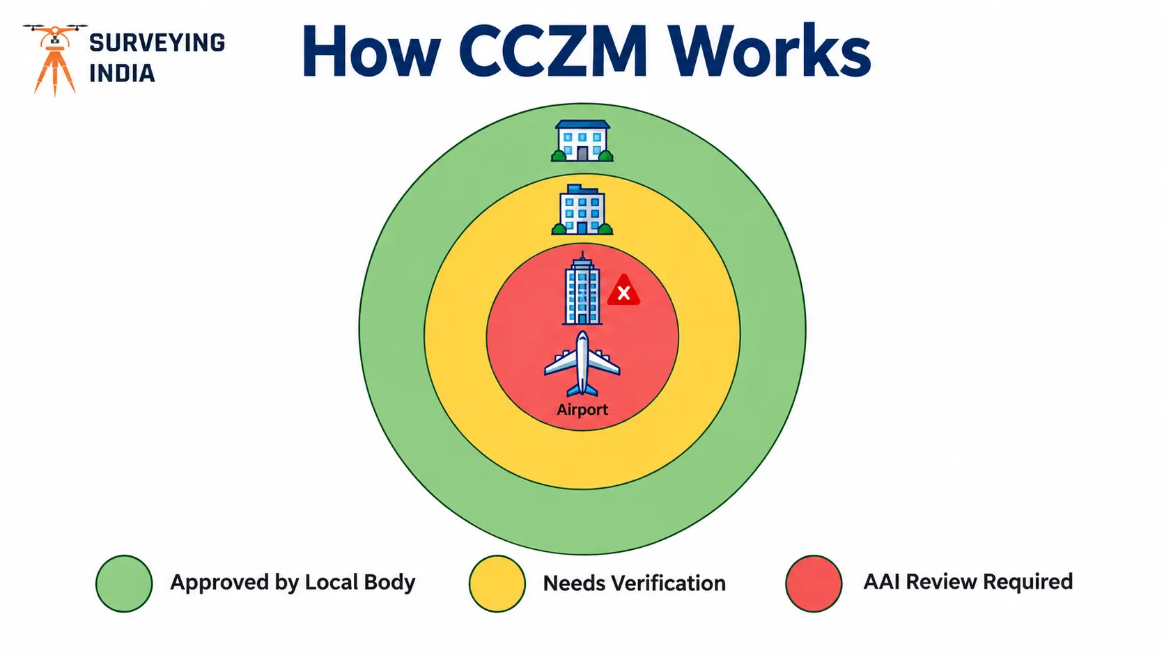
AAI’s actual CCZM documents use continuous elevation bands rather than a strict three-colour system. Even so, the practical outcome for applicants breaks down into three situations:
| Zone Outcome | What It Means | Next Step |
|---|---|---|
| Within permissible elevation (Green) | Your RTE sits below the PTE for your grid | Local municipal body can approve directly, no AAI reference needed |
| Borderline elevation (Yellow) | Your RTE sits close to or right at the PTE limit | Careful survey verification needed; even small errors can push you over the line |
| Exceeds permissible elevation (Red) | Your RTE sits above the PTE for your grid | You must apply to AAI through NOCAS for individual review |
The maximum elevation any CCZM can approve is capped at 150 metres AGL. So, even in a fully green zone, if your requested height crosses this ceiling, your application still needs NOCAS review rather than local approval.
CCZM vs the Check Approximate Elevation (CAE) Tool
NOCAS also offers a separate feature called Check Approximate Elevation (CAE). Applicants often confuse it with CCZM. Here’s the difference: CAE gives you an indicative elevation estimate, with a ceiling of around 300 metres AGL. It exists purely to help you plan your proposal before applying. The colour coded zoning map, on the other hand, is the actual, legally binding basis local bodies use to approve or reject your proposal without AAI’s involvement.
In other words, CAE helps you plan. CCZM helps your local authority decide. You still need a formal NOC through NOCAS if your site falls outside CCZM coverage, or exceeds its limits, no matter what the CAE tool indicates.
Which Local Bodies Use the Colour Coded Zoning Map?
Municipal and development authorities named in AAI’s CCZM guidelines, including the NDMC, MCD, and MCGM, directly reference CCZM data when clearing building proposals. This integration means your building sanction and your height clearance can move through a single window in cities where this system is active. You avoid two separate applications.
How CCZM Affects Different Structure Types
CCZM primarily governs buildings and general structures. Its logic extends to other categories too:
- Buildings and residential/commercial towers — the most common category covered by CCZM; see our building height clearance guide for structure-specific documentation.
- Transmission towers — height calculations follow the same PTE logic. Larger infrastructure projects often still require individual NOCAS review.
- Telecom masts — wireless masts follow a separate SACFA-integrated route, covered in our NOCAS documentation guide, rather than the standard CCZM process.
- Solar and wind energy projects — large-footprint projects, such as solar power installations and wind turbines, typically span multiple grid cells. Applicants should verify PTE across the entire project boundary, not just one point.
Which Cities Have a Published CCZM?
Coverage keeps expanding as AAI works through its list of major airports. Availability varies by city, so always confirm current CCZM status for your specific site before assuming automatic approval. Here’s how the colour coded zoning map plays out across India’s key metro and Tier-2 markets, along with our city-specific NOC guides for each.
Metro Cities
Major metro airports handle the highest construction volumes in India. This is exactly why CCZM adoption matters most here. In these cities, your local municipal body works directly with AAI’s grid data, so getting your RTE calculation right the first time saves real project time.
- Delhi NCR — IGI Airport’s CCZM integrates with NDMC and MCD approvals through the Common Application Form system.
- Mumbai — one of India’s most congested height-restricted zones, with CCZM data linked to MCGM’s building approval process.
- Bengaluru — covers both the civil airport and the co-located HAL airport, so grid elevation can vary sharply across the city.
- Ahmedabad — one of the earlier cities to receive a published CCZM, with well-established local body integration.
- Pune — rapid vertical development near the airport makes accurate RTE calculation especially important here.
Tier-2 and Growing Cities
CCZM coverage has extended well beyond the metros. Several fast-developing cities now fall under the same grid-based system. Even so, applicants in these cities should confirm current PTE data before filing, since expansion projects can shift boundaries over time.
- Jaipur, Lucknow, and Chandigarh — each has seen steady airport-adjacent commercial growth. CCZM verification is now a routine step for new projects here.
- Bhopal and Indore — both cities fall under AAI’s expanding CCZM rollout; confirm current grid data with our team before filing.
- Nagpur and Raipur — central India’s growing logistics and industrial hubs, where transmission and industrial structures often need extra scrutiny beyond standard CCZM limits.
- Patna, Varanasi, and Guwahati — Patna’s CCZM is publicly available through the state planning portal. Varanasi and Guwahati applicants should verify current status directly with AAI before filing.
- Surat, Kota, and Dholera — Dholera’s status as a planned smart city makes early CCZM verification especially valuable for large-scale developers.
If your project sits in any of these locations, start with the relevant city guide above. You’ll find local radius specifics, current CCZM status, and typical approval timelines.
When CCZM Doesn’t Apply to Your Site
Even in a city with an active CCZM, a few situations still require a full NOCAS application, regardless of your grid’s PTE:
- Your site falls near a defence aerodrome rather than a civil one — see our defence and IAF height clearance guide for that separate process.
- Your requested height exceeds the 150-metre AGL cap, even if it’s technically within your grid’s coloured zone.
- Your site falls within an airport’s approach or take-off funnel, where stricter obstacle limitations apply regardless of the general CCZM elevation for that area.
- Your city or airport doesn’t have a published CCZM yet. In that case, every application routes through standard NOCAS review.
A CCZM approval and an AAI NOC achieve the same legal outcome through different paths. One goes through your local body, the other through AAI directly. Neither one substitutes for proper site survey data.
Why Accurate Survey Data Still Matters with CCZM
Here’s the catch that trips up many applicants. Your local body approves your proposal based on the RTE you submit. AAI calculates this from your site’s actual ground elevation plus your structure’s height. If that ground elevation figure is wrong, even slightly, your RTE calculation shifts. What looked like a comfortably green zone site can turn out to exceed the PTE. A certified site elevation survey protects you from this risk before you submit anything to your local body.
How Surveying India Helps You Use CCZM Correctly
Our team checks colour coded zoning map applicability for your exact coordinates before you approach your local municipal body. You’ll know upfront whether you can skip AAI reference entirely, or need to prepare for a full NOCAS application. We combine RTK-GNSS survey data, accurate to within ±5 cm, with current CCZM grid data to calculate your precise RTE. This way, you avoid submitting a proposal that looks compliant on paper but fails technical scrutiny later. Explore our full Airport NOC survey services for end-to-end support across both CCZM and NOCAS routes.
Frequently Asked Questions
What is the colour coded zoning map AAI publishes? The colour coded zoning map AAI publishes is a grid-based map showing the Permissible Top Elevation for locations around a civil airport. It lets local municipal bodies approve building proposals directly, without referring to AAI, as long as the requested height stays within the mapped limit.
What is the maximum height CCZM can approve? CCZM can approve heights up to 150 metres AGL. Anything above that requires a full NOCAS application to AAI, regardless of the grid’s colour zone.
What’s the difference between PTE and RTE? PTE (Permissible Top Elevation) is the maximum height AAI’s map allows for a location. RTE (Requested Top Elevation) is your proposed structure’s actual top elevation. Your RTE must stay at or below the PTE for local approval.
Which cities have a published CCZM? Around 30 major airports across India currently have a published CCZM. This includes Ahmedabad, Bengaluru, Bhopal, Bhubaneswar, Chennai, Kochi, and Patna, with coverage expanding over time.
Is CCZM the same as an AAI NOC? Not exactly. CCZM lets your local municipal body approve your proposal on AAI’s behalf, based on pre-calculated elevation data. An AAI NOC, by contrast, comes directly from AAI through NOCAS review.
What is the Check Approximate Elevation (CAE) tool? CAE is an indicative planning tool in NOCAS, with a ceiling of around 300 metres AGL. It helps you estimate elevation before applying, but it isn’t a substitute for CCZM’s legally binding data.
Do I still need a survey if my site falls in a CCZM zone? Yes. Your local body approves your proposal based on the RTE you submit. Accurate ground elevation and coordinate data remain essential, even within a CCZM-covered area.
Does CCZM apply to defence airports? No. CCZM covers civil aerodromes only. Sites near defence airfields follow a separate clearance process through the Ministry of Defence.
Want to know if your site qualifies for direct municipal approval under CCZM? Talk to our survey team — we’ll check your exact coordinates against the current CCZM data and guide you to the fastest approval route.