LiDAR Survey vs Drone Survey: Which One Is Right for Your Project in Nagaland?
By the Surveying India Team | Precision Geospatial Solutions, 10+ Years in the Field
Choosing between LiDAR survey vs drone survey is one of the first decisions you’ll face when planning a project in Nagaland. A highway alignment near Dimapur, a resort on a forested hillside, or a mining site in the hills — each one raises the same practical question. Which technology gives you the right data?
It’s a fair question. Both technologies fly through the same skies. Both produce accurate maps of the ground below. But they solve different problems. Pick the wrong one and you risk weeks of rework, an incomplete dataset, or a design based on a terrain model that missed what was hiding under the tree canopy.
This guide breaks down the LiDAR survey vs drone survey decision in plain terms. We’ll cover how each technology works, where each one wins, and how the choice shifts once you factor in Nagaland’s mix of open plains, dense forest, and steep hill terrain around growth corridors like Dimapur.
LiDAR Survey vs Drone Survey: The Short Answer
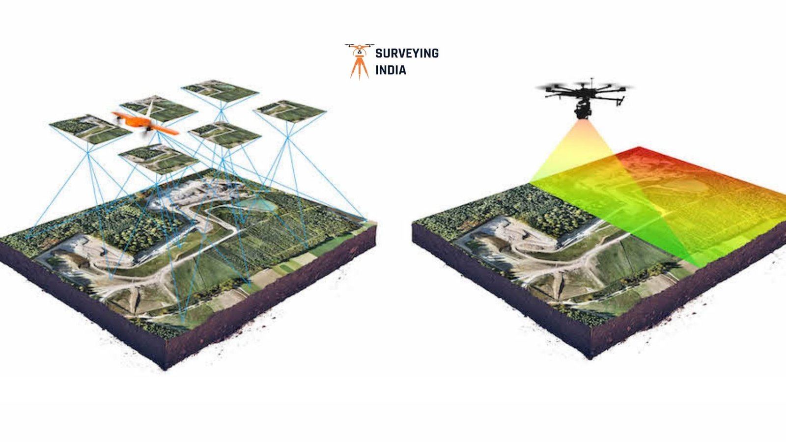
LiDAR survey uses laser pulses to measure the ground directly. Those pulses slip through small gaps in vegetation and reach the earth beneath. That makes LiDAR the stronger choice for forested hills, dense canopy, and sites where you need the true bare-earth elevation — not just what’s visible from above.
Drone survey (photogrammetry) uses overlapping high-resolution photographs to reconstruct the surface. It deploys faster, costs less, and produces excellent visual detail. But it can only “see” what the camera sees. Under a forest canopy, a drone survey maps the top of the trees, not the ground.
Here’s the simple rule. If your site is open or lightly vegetated, a drone survey usually gets the job done faster and cheaper. If your site has forest cover or terrain where a few centimeters of missing elevation data could affect drainage or structural design, LiDAR earns its higher cost. Many projects in Nagaland end up using both — drone imagery for visual context, LiDAR for the terrain truth underneath.
How LiDAR Survey Works
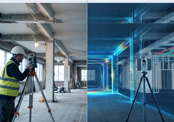
LiDAR stands for Light Detection and Ranging. A sensor — mounted on a drone, aircraft, vehicle, or tripod — fires hundreds of thousands of laser pulses per second at the ground. It measures how long each pulse takes to bounce back. That timing data becomes a dense “point cloud.” Millions of individually measured 3D points form a digital replica of the terrain.
Why LiDAR Sees Through the Trees
The defining advantage of LiDAR is penetration. Even under fairly closed forest canopy, small gaps between leaves and branches let enough laser pulses reach the ground. Software then classifies each point as “ground,” “vegetation,” or “structure,” and filters out everything except the bare earth. The result is a clean digital terrain model. It shows what the land looks like beneath the trees — something a camera cannot capture.
This is why LiDAR has become the standard tool for forestry departments and landslide-prone hill districts. Civic bodies have also turned to LiDAR for large-scale property documentation. Navi Mumbai’s municipal corporation, for example, used LiDAR survey data specifically to identify structural changes in properties for tax assessment. The technology captured detail that manual methods missed.
For the process, deliverables, and applications specific to this region, see our detailed LiDAR survey in Dimapur page.
How Drone Survey (Photogrammetry) Works
A drone survey uses a UAV fitted with a high-resolution camera. The drone flies a pre-planned grid pattern over a site and captures hundreds or thousands of overlapping photographs. Photogrammetry software stitches these images together. It uses the overlap to triangulate elevation and generate an orthomosaic — a seamless, geo-corrected aerial photo — along with a 3D surface model.
Where Drone Survey Wins
The strength of drone survey is speed, cost, and visual richness. It relies on standard cameras rather than specialized laser sensors. That makes it faster to deploy and more budget-friendly than LiDAR, especially for small to mid-sized sites. The imagery is also useful beyond elevation data alone. Stakeholders can visually inspect the photographed surface, which helps with site documentation, progress monitoring, and client presentations.
The limitation is simple. A camera only captures what it can see. On open plots, cleared industrial land, quarries, and urban areas, that’s rarely a problem. But on any site with meaningful vegetation, a drone survey maps the canopy top — not the ground beneath it — unless paired with LiDAR.
For the full breakdown of services in this region, see our drone survey in Dimapur page.
LiDAR Survey vs Drone Survey: Side-by-Side Comparison
| Factor | LiDAR Survey | Drone Survey (Photogrammetry) |
|---|---|---|
| Best for | Forested, hilly, or vegetated terrain | Open, cleared, or lightly vegetated sites |
| Penetrates vegetation | Yes — reaches bare earth through canopy gaps | No — maps the visible surface only |
| Typical vertical accuracy | 2–5 cm | 5–8 cm |
| Typical horizontal accuracy | 5–10 cm | 3–5 cm |
| Speed of deployment | Moderate — needs specialized sensors | Fast — standard camera-equipped UAVs |
| Relative cost | Higher | Lower |
| Visual imagery output | Limited | Rich, photorealistic orthomosaics |
| Ideal applications | Forestry, landslide zones, drainage design, dense hillside corridors | Land layout, quarry volumetrics, urban mapping, progress monitoring |
Why Nagaland’s Terrain Makes This Choice Harder
Dimapur sits at an unusual geographic hinge point. The flat edge of the Brahmaputra plains gives way, almost immediately, to the forested hill ranges that define the rest of Nagaland. Few Indian cities ask a survey team to handle both extremes within the same district.
Highway and Road Corridors
Sections connecting to NH-29 often start on open plains and climb into forested hill terrain within a few kilometers. A single project may genuinely need drone photogrammetry on the lower stretch and LiDAR on the upper, forested stretch.
Landslide and Slope Monitoring
Landslide risk is a growing concern across the Northeast’s hill districts. Elsewhere in India, state disaster management authorities have turned to drone-based LiDAR survey specifically to study land subsidence and landslide risk. Standard photography can’t reveal what’s happening on a vegetated, unstable slope. LiDAR can.
Forestry and Agricultural Land
Monitoring Nagaland’s dense forest belt is a canopy-penetration problem by definition. This plays directly to LiDAR’s core strength, and it pairs naturally with our multispectral & NDVI survey solutions for vegetation health analysis.
Urban and Industrial Plots
Cleared land, existing infrastructure, and quarry sites around Dimapur itself are usually open enough for drone survey to deliver everything needed, faster and at lower cost.
In short: let terrain type — not budget — be your first filter. Then let cost, timeline, and deliverable format narrow the decision from there.
Practical Guidance: How to Choose
Choose LiDAR survey if:
- Your site has forest cover, dense vegetation, or a mixed hill-and-canopy landscape
- You need bare-earth accuracy for drainage design, cut-and-fill, or grading work
- You’re assessing landslide risk or slope stability
- Your project involves forestry, canopy height modeling, or land-use change tracking
Choose drone survey if:
- Your site is open, cleared, or lightly vegetated
- You need fast turnaround and a lower budget
- You want rich visual imagery alongside elevation data
- You’re calculating stockpile or excavation volumes on a mining or quarry site
- Your project is urban or industrial, with clear sightlines from the air
Combine both if:
- Your project spans multiple terrain types — a common scenario for highway corridors and township developments around Dimapur
- You need LiDAR’s bare-earth accuracy and drone photography’s visual context in one package
Our total station survey and contour survey services can complement either method. They provide ground-truthed control points that anchor your aerial data to survey-grade accuracy.
Accuracy Standards and Compliance
Whichever method you choose, your data should meet recognized geospatial accuracy benchmarks. DGCA regulations govern all drone operations in India, covering registration, airspace clearance, and pilot certification. This is non-negotiable near restricted zones such as airports, where our Airport NOC survey team handles height-clearance documentation directly.
On the technical side, the USGS LiDAR overview remains a clear public reference for how LiDAR data is captured, classified, and used worldwide. The Survey of India sets the national benchmark for mapping and geodetic standards that professional surveys in the country follow.
LiDAR Survey vs Drone Survey: Why Choose a Team That Offers Both
The honest answer to “LiDAR survey vs drone survey?” is usually “it depends on your site.” That’s exactly why it helps to work with a survey partner who isn’t trying to sell you just one technology.
Surveying India has spent over a decade delivering both LiDAR and drone survey projects across India. We run a fleet of 10 LiDAR and drone units, employ DGCA-certified pilots, and have completed more than 800 projects across infrastructure, mining, real estate, and government mandates. That combination means you get a recommendation based on your terrain and your project goals — not on whichever single piece of equipment happens to be available. Learn more about our company and the standards we hold every deliverable to.
For projects around Dimapur and the wider Nagaland region, our teams already know the local monsoon windows, forest-zone access restrictions, and the documentation standards that government and infrastructure clients expect. That means less time spent on logistics and more time spent on the data itself.
Frequently Asked Questions
Is LiDAR always more accurate than drone survey? Not necessarily. Accuracy depends on site conditions, not just the technology. On open, unobstructed terrain, well-executed drone photogrammetry can match or come close to LiDAR accuracy at a lower cost. LiDAR pulls ahead where vegetation or obstruction is present, since it measures ground that a camera can’t see.
Can drone survey work in forested areas? Yes, but with a caveat. A standard drone survey maps the top of the canopy, not the ground beneath it. If you need bare-earth data in a forested site, you’ll need a LiDAR-equipped drone rather than a standard photogrammetry drone.
Which option costs less for a small project near Dimapur? Drone photogrammetry is usually the more cost-effective choice for small, open sites. It doesn’t require specialized laser sensors. LiDAR earns its added cost specifically when vegetation or terrain complexity would compromise a photogrammetry-only result.
Can I get both LiDAR and drone data in the same survey? Yes. Many projects — particularly highway corridors and township developments that span open and forested terrain — combine LiDAR-equipped drones with standard photogrammetry passes. This gives you bare-earth accuracy and photorealistic visual context in one deliverable package.
How do I know which method my project needs? Start with terrain. Heavily vegetated or hilly sites lean toward LiDAR. Open or cleared sites lean toward drone survey. Beyond that, consider your project goals. Drainage design and slope analysis favor LiDAR’s bare-earth accuracy. Layout planning and volumetric tracking often work well with drone photogrammetry alone. A free site assessment is the fastest way to get a definitive answer.
Get Expert Advice Before You Choose
Picking between LiDAR survey and drone survey doesn’t have to be a guessing game. Tell us about your site — its terrain, size, and what the data needs to support. Our team will recommend the right approach, or the right combination, before a single flight is planned.
Request a Free Site Assessment → | Explore All Survey Services →