Project Overview
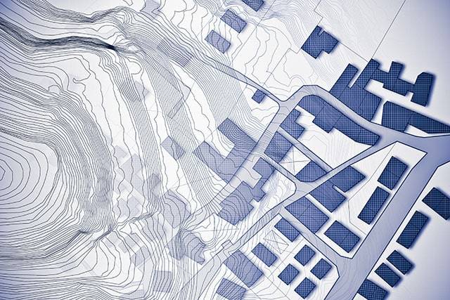
A Contour Survey (also known as a Detail Survey or Topographic Survey) depicts the features and structures on and around a parcel of land.
The quantity of information displayed varies based on the user’s needs, but it can include the location of buildings, windows, driveways, walls, trees, and natural surface features such as watercourses, embankments, rock outcrops, and contours.
A Contour Survey is needed for a number of reasons.
It is typically submitted with a Development Application (DA) to Council or as a provision to an Architect or Engineer for building and infrastructure design. Flood studies, comprehensive landscape design, and structural engineering may also necessitate it.
Our surveys are as unique as each land parcel.
To make the procedure as simple as possible, we customize each survey to your individual needs and give easy-to-read plans and well-structured CAD models.
The Contour Survey Methodology
- Determine the goal and scope of the survey, as well as the survey cost.
- Site survey and measurements will be performed during this visit.
- Calculations in the office, plan writing, and quality assurance
- Contour Survey plan distribution in electronic (PDF and DWG) formats.
Surveying India – Contour Survey/Topographic Survey Services in Delhi NCR
Surveying India is a trusted name in the field of Contour Survey and Topographic Survey Services in Delhi NCR. Our expertise in these surveying techniques provides invaluable data for planning, designing, and executing various projects in construction, engineering, and environmental management.
What is a Contour Survey?
A contour survey, also known as a topographic survey, involves mapping the elevation of the land and its natural and man-made features. This type of survey produces contour lines on a map, representing the terrain’s shape and elevation, which is crucial for understanding the land’s topography.
Our Contour/Topographic Survey Services
At Surveying India, we offer comprehensive contour and topographic survey services that cater to diverse project needs. Our services include:
- Elevation Mapping
We create detailed elevation maps that illustrate the land’s contours, helping in the planning and design of infrastructure projects. - Land Feature Identification
Our surveys identify and map natural features like hills, valleys, rivers, and artificial structures, providing a complete picture of the terrain. - Site Planning and Analysis
We assist in site planning by providing accurate topographic data, which is essential for determining suitable locations for construction and development. - Infrastructure Development
Our contour surveys support infrastructure projects such as roads, bridges, and drainage systems by providing precise terrain data. - Environmental and Agricultural Planning
We help in environmental conservation and agricultural planning by mapping land use, soil erosion, and water flow patterns.
Why Choose Surveying India for Contour/Topographic Surveys?
- Experienced Surveyors
Our team consists of skilled surveyors with extensive experience in conducting contour and topographic surveys for various industries. - Advanced Technology
We utilize the latest surveying equipment and software to deliver high-accuracy results. - Customized Solutions
We understand the unique requirements of each project and provide tailored surveying solutions to meet specific needs. - Timely and Accurate Data
We are committed to delivering precise and reliable survey data within the agreed timelines, ensuring project efficiency.
Applications of Contour/Topographic Surveys
Contour and topographic surveys are essential in multiple sectors, including:
- Construction and Engineering
Providing critical data for the design and construction of buildings, roads, and infrastructure. - Urban and Regional Planning
Assisting in the development of urban layouts and regional development plans. - Environmental Management
Supporting environmental impact assessments and conservation efforts. - Agriculture
Enhancing land use planning, irrigation design, and soil conservation practices.
Contact Us
For reliable Contour Survey/Topographic Survey Services in Delhi NCR, Surveying India is your trusted partner. Our dedication to accuracy, professionalism, and client satisfaction sets us apart.
Contact us today to learn more about our services and how we can assist with your next project using our expert contour and topographic survey solutions.