
Two sites, both 30 km from their nearest airport. One needs an AAI NOC. The other doesn’t. Why? The VFR IFR airport NOC distance rule is the reason, and it trips up more applicants than almost any other part of the process.
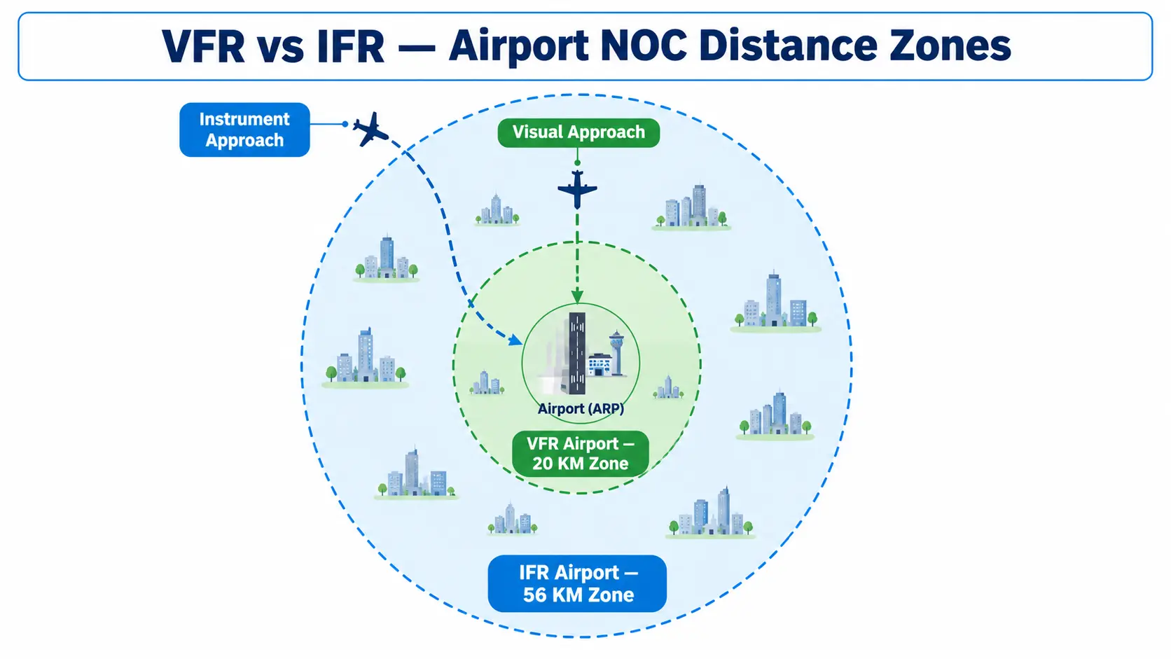
Your NOC distance requirement depends on whether your nearest airport operates under Visual Flight Rules (VFR) or Instrument Flight Rules (IFR). VFR airports carry a 20 km safeguarding radius. IFR airports carry a much larger 56 km radius. Get this classification wrong, and you’ll either file an unnecessary application or, worse, skip one you actually needed.
This guide breaks down exactly what separates a VFR airport from an IFR airport. You’ll also learn why the distance zones differ so much, and how to figure out which one governs your project.
What is a VFR Airport?
A VFR (Visual Flight Rules) airport handles aircraft that navigate primarily by looking outside the cockpit. These airports don’t rely on instrument-guided approach systems. Pilots need clear weather and good visibility to land here. Because these airports don’t support complex instrument approach procedures, their protected airspace footprint stays comparatively small.
Under GSR 751(E), any VFR aerodrome carries a 20 km NOC radius, measured from its Aerodrome Reference Point (ARP). Smaller domestic airports, flying clubs, and select state-run airstrips typically fall into this category.
What is an IFR Airport?
An IFR (Instrument Flight Rules) airport supports aircraft that navigate using onboard instruments and ground-based or satellite navigation aids. These aircraft can land even in poor visibility or at night. This capability demands a much larger protected corridor. Aircraft descend gradually along a structured approach path that can stretch for dozens of kilometres before touchdown.
Consequently, GSR 751(E) sets the NOC radius for IFR aerodromes at 56 km from the ARP. Nearly every major international and domestic hub in India, including Delhi, Mumbai, Bengaluru, Hyderabad, and Chennai, operates under this classification. The International Civil Aviation Organisation (ICAO) sets the global technical standards for instrument approach and obstacle limitation requirements. India’s Directorate General of Civil Aviation (DGCA) adopts these standards through its own Civil Aviation Requirements.
VFR vs IFR Airport NOC Distance: Quick Comparison
| Factor | VFR Airport | IFR Airport |
|---|---|---|
| Navigation method | Visual reference to ground and horizon | Instrument and navigation-aid guided |
| NOC radius from ARP | Up to 20 km | Up to 56 km |
| Typical examples | Smaller domestic airports, flying clubs, select state airstrips | Delhi, Mumbai, Bengaluru, Hyderabad, Chennai, and other major hubs |
| Weather dependency | Requires clear visibility to operate | Can operate in low visibility and at night |
| Why the radius differs | Shorter, more direct approach paths | Longer, structured descent paths requiring extended obstacle protection |
Why the Distance Zones Differ So Much
This is where a lot of applicants get confused. It isn’t simply about airport size or how busy the airport is. Instead, it comes down to how aircraft approach the runway.
At a VFR airport, pilots see the runway visually and adjust their approach in real time. This keeps the obstacle-sensitive corridor relatively short and close to the airport itself. At an IFR airport, however, aircraft follow a precisely calculated glide path, guided by instruments. This descent often begins tens of kilometres out. Any obstruction along that extended path, even one far from the runway, can interfere with the aircraft’s instrument-guided descent. So, GSR 751(E) extends the safeguarding radius accordingly, to 56 km, for exactly this reason.
How to Find Out If Your Nearest Airport is VFR or IFR
Before you can determine your applicable radius, you need to know your nearest airport’s classification. Here’s how to check:
- Identify your nearest civil aerodrome. Note that “nearest” isn’t always obvious in dense regions with multiple nearby airports.
- Check the airport’s operational classification. Most major airports operate under IFR. Smaller regional airports and airstrips are more likely to be VFR-only.
- Confirm through AAI or NOCAS directly. Since classifications can change as smaller airports upgrade their navigation infrastructure, always verify current status rather than relying on outdated information.
- Account for overlapping zones. If your site falls within the safeguarding radius of more than one airport, whichever produces the stricter height restriction governs your project.
Getting this step wrong causes real problems. Applicants either file unnecessary NOCAS applications, or they skip a required one entirely. A quick feasibility check before you proceed avoids both mistakes.
The 150-Metre Auto-Settle Rule
Distance from the airport isn’t the only factor. Height matters too. If your site sits beyond the applicable VFR or IFR distance zone, your height still matters. When your proposed structure stays at or below 150 metres above ground level (AGL), NOCAS auto-settles your case automatically. The system issues a letter confirming that you don’t need an NOC, without any manual review.
There’s a separate, tighter rule for wireless telecom masts. These auto-settle if the mast sits beyond 10 km from a VFR airport and stays below 100 metres in height. If your project doesn’t meet either of these auto-settle conditions, you’ll need to file through NOCAS for formal review.
What Happens Within the Distance Zone
Once you confirm your site falls within the applicable VFR or IFR radius, your permitted height isn’t a flat number across the entire zone. It decreases the closer your site sits to the runway, following the airport’s Obstacle Limitation Surface. Near the immediate vicinity of the runway strip, an outright no-construction zone typically extends roughly 500 metres in every direction.
For select cities, AAI has also published a Colour Coded Zoning Map (CCZM). This lets your local municipal body approve lower-height proposals directly, without referring your case to AAI at all.
Common Mistakes with VFR vs IFR Distance Zones
- Assuming a small airport is automatically VFR. Some smaller airports have upgraded to instrument approach capability over time. Always verify current classification rather than assuming based on airport size alone.
- Measuring distance from the wrong point. NOCAS measures strictly from the Aerodrome Reference Point, not from the nearest runway threshold or terminal building.
- Ignoring overlapping zones near multiple airports. In regions with more than one nearby aerodrome, applicants sometimes check only the closer airport and miss a farther one with a larger IFR radius that still applies to their site.
- Confusing the 150m auto-settle rule with a blanket exemption. Sites beyond the distance zone still need to meet the height condition. A tall structure beyond 56 km can still require an NOC if it exceeds 150 metres AGL.
Why This Matters for Your Project
Getting your VFR vs IFR classification right, early, saves real project time. If you incorrectly assume your site sits in a smaller VFR zone, when it actually falls under a 56 km IFR radius, you risk a real problem. You could start construction without a required NOC, exposing your project to potential demolition orders down the line. On the other hand, mistakenly assuming you need an NOC wastes time too. If your site actually sits beyond the applicable zone, you’ll end up filing an unnecessary application.
Our city-specific guides help you confirm which classification applies where you’re building, including Delhi NCR, Mumbai, Jaipur, and Kota, among others.
How Surveying India Confirms Your Applicable Zone
Before you file anything, our team identifies your nearest airport, confirms its VFR or IFR classification, and calculates your exact distance from its Aerodrome Reference Point using certified GPS survey data. This tells you upfront whether you fall under the 20 km or 56 km radius. You’ll also know whether the 150-metre auto-settle rule applies to your site, and whether a CCZM lets your local body approve your project directly. Explore our complete Airport NOC survey services for end-to-end support, from classification confirmation through to final NOC approval.
Frequently Asked Questions
What is the VFR IFR airport NOC distance rule? It’s the framework under GSR 751(E) that sets your NOC safeguarding radius based on airport type: up to 20 km for VFR airports, and up to 56 km for IFR airports, measured from the Aerodrome Reference Point.
How do I know if my nearest airport is VFR or IFR? Most major domestic and international airports operate under IFR. Smaller regional airports and airstrips are more often VFR-only. Confirm current classification through AAI or NOCAS, since it can change as airports upgrade their navigation infrastructure.
Why is the IFR radius so much larger than the VFR radius? IFR aircraft descend along a structured, instrument-guided approach path that can extend tens of kilometres from the runway. This requires a much longer obstruction-free corridor than a VFR aircraft’s shorter, visually guided approach.
What happens if my site falls within two overlapping airport zones? Whichever airport produces the stricter height restriction governs your project. You can’t rely on the more lenient of the two zones.
Do I need an NOC if my site sits beyond the VFR or IFR radius? Generally no, provided your proposed structure stays at or below 150 metres AGL. NOCAS auto-settles such cases automatically.
Does the auto-settle rule apply to telecom masts too? Yes, but with tighter limits. Wireless telecom masts auto-settle only if they sit beyond 10 km from a VFR airport and stay below 100 metres in height.
Can a VFR airport later become an IFR airport? Yes. As airports add instrument approach infrastructure, their classification, and therefore their applicable NOC radius, can change. Always verify current status before filing.
Where is the distance measured from exactly? NOCAS measures distance from the airport’s Aerodrome Reference Point (ARP), not from the nearest runway threshold, terminal building, or airport boundary fence.
Not sure whether your site falls under a VFR or IFR radius? Reach out to our survey team — we’ll confirm your nearest airport’s classification and your exact distance before you file anything.