
BIM (Building Information Modelling) LiDAR Scanning Services in Delhi, Gurgaon, Noida & Mumbai
Building Information Modeling (BIM) combined with LiDAR scanning creates highly accurate, millimeter-level 3D digital models of buildings, infrastructure, and construction sites. This technology helps architects, engineers, and contractors plan, design, and manage projects with greater precision and fewer costly errors. Surveying India provides BIM LiDAR scanning services across Delhi, Gurgaon, Noida, and Mumbai, using advanced mobile and handheld LiDAR scanners to deliver fast, reliable, as-built 3D data for construction, renovation, and facility management projects.
What is BIM LiDAR Scanning?
BIM LiDAR scanning utilizes laser-based technology to capture high-definition 3D scans of buildings, infrastructure, and landscapes. This data is then integrated into BIM models to create digital twins for project planning, design verification, and facility management.
Benefits of LiDAR and BIM Scanning Services
- High Precision & Accuracy – Advanced LiDAR scanning services capture detailed 3D models with millimeter-level accuracy.
- Time-Efficient Surveying – Drone survey services quickly scan large areas, reducing project turnaround time.
- Improved Project Planning – Scan to BIM services help architects and engineers make better decisions with reliable data.
- Cost-Effective Solutions – Accurate data reduces errors, minimizing rework and saving project costs.
- Enhanced Safety – Ideal for surveying hazardous or hard-to-reach areas without human risk.
Our BIM LiDAR Scanning Services
At Surveying India, we provide state-of-the-art BIM LiDAR scanning services across Delhi, Gurgaon, Noida, and Mumbai. Our services include:
- 3D Laser Scanning for BIM – High-resolution data collection for accurate architectural and structural modeling.
- Scan-to-BIM Services – Converting LiDAR scan data into intelligent 3D BIM models.
- As-Built Documentation – Providing detailed models of existing structures for renovation and restoration projects.
- Infrastructure & Construction Scanning – Capturing precise measurements for bridges, roads, and large-scale infrastructure projects.
- MEP (Mechanical, Electrical & Plumbing) Scanning – Mapping utility networks and hidden infrastructure elements.
Why Choose Surveying India?
As the best land survey company in India, Surveying India offers unparalleled expertise in BIM LiDAR scanning. Here’s why we are the preferred choice:
✔ Cutting-Edge Technology – We utilize advanced LiDAR scanners and software for high-resolution 3D mapping.
✔ Experienced Professionals – Our team comprises industry experts specializing in BIM and geospatial analytics.
✔ Customized Solutions – We tailor our scanning services to meet the specific needs of your project.
✔ Fast & Reliable Service – We ensure quick turnaround times without compromising on quality.
✔ Nationwide Coverage – Offering services in Delhi, Gurgaon, Noida, Mumbai, and other cities across India.
Our Recent BIM LiDAR Projects
Karol Bagh Metro Station – LiDAR BIM Survey, Delhi
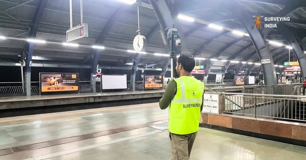
When it comes to surveying a live, high-footfall public transit facility, precision and speed both matter equally — and that’s exactly the challenge our team tackled at Karol Bagh Metro Station in Delhi. Using an advanced mobile LiDAR scanning setup, our surveyors captured a complete 3D point cloud of the station’s platform, structural framework, ceiling architecture, and surrounding infrastructure — all while the station remained fully operational and open to commuters.
Every beam, signage panel, ceiling truss, and platform edge was digitized into millions of accurate data points, later converted into a detailed BIM model. This kind of as-built documentation is invaluable for metro authorities and infrastructure teams — it becomes the foundation for structural health assessments, future renovation or expansion planning, and long-term facility management, without ever needing to shut down operations or disrupt daily commuter traffic.
What made this project stand out was the ability to work discreetly and efficiently in a live public environment — balancing safety protocols, limited access windows, and constant crowd movement, while still delivering millimeter-level scanning accuracy. It’s a strong example of how BIM LiDAR scanning goes beyond new construction and plays a critical role in maintaining and modernizing India’s growing metro infrastructure.
Building BIM Scanning, Gurgaon
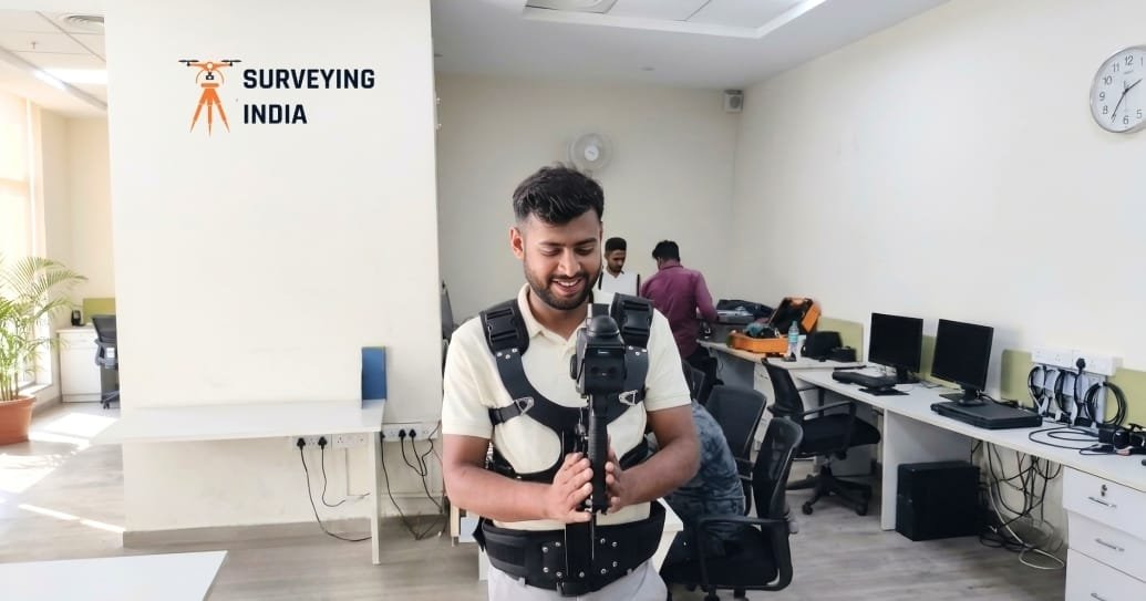
For a corporate office space in Gurgaon, our team carried out a complete interior BIM LiDAR scan to create an accurate, as-built digital model of the entire workspace. Using a body-worn LiDAR scanning system, our surveyor walked through the office capturing real-time 3D data — mapping everything from wall layouts, ceiling heights, and column positions to MEP elements like electrical points, HVAC ducting, and plumbing lines that are often invisible in outdated floor plans.
This kind of detailed scan is especially valuable for organizations planning office renovations, space optimization, or facility upgrades, where relying on old architectural drawings can lead to costly errors. With a millimeter-accurate 3D BIM model in hand, architects, interior designers, and facility managers can plan layout changes, furniture placement, and MEP modifications with complete confidence — no guesswork, no on-site remeasurement, and far fewer surprises during execution.
The entire scan was completed quickly with minimal disruption to the ongoing office operations, showcasing how BIM LiDAR technology can turn a time-consuming manual measurement process into a fast, accurate, and hassle-free digital workflow — even in busy, occupied commercial spaces.
Frequently Asked Questions – BIM LiDAR Scanning Services
What is BIM LiDAR scanning?
BIM LiDAR scanning uses laser-based technology to capture millions of precise 3D data points (a point cloud) of a building, structure, or site. This point cloud is then converted into an intelligent BIM (Building Information Modeling) model that architects, engineers, and contractors use for design, planning, and facility management.
What is Scan-to-BIM?
Scan-to-BIM is the process of converting raw LiDAR point cloud data into a structured, editable 3D BIM model in software like Autodesk Revit. It allows teams to work with accurate as-built data instead of relying on outdated drawings.
How accurate is LiDAR scanning?
Our LiDAR scanning services deliver millimeter-level accuracy, making them suitable for architectural documentation, MEP coordination, renovation projects, and infrastructure surveys where precision is critical.
Which areas do you cover for BIM LiDAR scanning?
We provide BIM LiDAR scanning services across Delhi, Gurgaon, Noida, Mumbai, and other major cities in India, serving construction, architecture, and infrastructure projects of all sizes.
How long does a BIM LiDAR survey take?
Turnaround time depends on the size and complexity of the site. Small to mid-size buildings typically take a few days for on-site scanning, with the full BIM model delivered within 1–3 weeks depending on detail requirements.
What industries use Scan-to-BIM services?
Scan-to-BIM is widely used in construction, architecture, real estate, infrastructure development, facility management, and renovation/restoration projects where accurate as-built data is essential.
Contact Us
For high-precision BIM LiDAR scanning services in Delhi, Gurgaon, Noida, and Mumbai, trust Surveying India – Best Land Survey Company in India. With years of hands-on experience across metro infrastructure, commercial buildings, and large-scale construction projects, our team delivers millimeter-accurate 3D data you can rely on for confident design, planning, and facility management decisions. From initial site scanning to final BIM model delivery, we ensure fast turnaround times, transparent communication, and results that stand up to the demands of your project.
Contact us today to discuss your project and get the most advanced scanning solutions for your needs.